The Wild East Rodungla Trek is one of the interesting trek in Bhutan. The trek takes trekkers from the central region of Bumthang to the eastern region of Trashiyangtes. The trek takes you across the northern topmost regions of eastern Bhutan taking trekkers through the ancient important trade route. Prior to the construction of new expressway and unsealed roads among the regions, the trek is more likely to visit the remotes parts of the regions. The trek offers many exciting opportunity to visit some of the remote villages, ancient golden roofed monasteries and temple dotted around the hillside and with enough flora and fauna. The best time to embark on this trek is March – April and October
Duration: 15 Days / 14 Nights
Detailed Itinerary
Day 01: Paro – Thimphu
Today at your arrival, you will be welcomed by our local representative at the Paro International Airport and after a short introduction you will be driven to Thimphu the capital city which lies at an altitude of 7700ft/2350m is only 55 Km long and is negotiable in 1.5 hours. The capital of Thimphu is home for more that 80,000 population and you will soon notice that it is unlike most capital cities of the world. The capital lies in a steep valley with alpine forest and numerous golden roofed temples and monasteries and the capital possess the real charm. Reaching your hotel check in and after a short rest in the hotel drive to visit the impressive Memorial Chorten(stupa) built in memory of the third king of Bhutan in 1974. This stupa is visited by people from all walks of lives and is one of the most public religious place in the country. From here take the road to Changangkha Lhakhang which is considered to be one of the oldest temple in Thimphu and was built in twelve century. Located above the city the place has an air of peace and tranquility. From the temple drive to visit the Trashichhoe Dzong, which is your last stop of the day and usually open to the visitors after five pm in the evening. This giant impressive fortress is locally known as the “fortress of the glorious religion”. It houses the throne room of the king and the central monk body.
Day 02: Thimphu – Bumthang
Your drive takes you crossing Dochula Pass, which lies at an elevation of 10150ft/3100m. The beautiful pass offer one hundred and eight chorten (stupas) built by the eldest Queen Mother Ashi Dorji Wangmo Wangchuk along with Druk Wangyel Lhakhang (temple) lies above the parking lot. Beside this magnificent chorten(stupas) in an amazing setting you will be able to spot some of the great Himalayan peaks like – Mt. Masa Gang(235012ft/7165m), Mt. Tsenden Gang(23228ft/7100m). Mt. Teri Gang(23944ft/7300m), Mt. Zongaphu Gang the “Table Mountain”(23288ft/7100m), Mt. Gangkhar Puensum(24735ft/7541m), and many other permanent peaks of Himalayas like – Mt. Jejegangphu, Mt. Kangphug Gang. From the lofty pass the downhill drive takes you through Lobesa village under Punakha (5000ft/1525m) and then cross the Wangdue province through dramatic landscape with scenic beauty and scattered settlements unfolds along the route and finally takes you up through Black Mountain via Pele La Pass (11070ft/3375m) which is marked by a small chorten(stupa) and prayer flags. You descent downhill through slopes covered with bamboos, which is the favorite food for the yaks in the vicinity and passing through several impressive landscape and scattered settlement you will finally reached Trongsa(6800ft/2073m). The valley is enriched by natural beauty and was home for the past royal family. This historically recognized place today is transformed into culturally significant icon. Visit the impressive Trongsa Dzong built in the mid-sixteenth century. From here your drive takes you uphill till you reached Yotung La Pass(11000ft/3354m) and then finally descent down to Bumthang valley through passing another Keki La Pass(9300ft/2835m) and then to the main centre of Bumthang the Jakar Valley which lies at a cool 8450ft/2576m).
Day 03: Toktu Zampa – Ngang Lhakhang
Today after your breakfast drive further north end of Chamkhar town until you meet with your trekking crew at Toktu Zampa where you will start your trekking. The trail takes you through the Chamkhar Chhu (river), through many settlements, ancient golden roofed temples dotted around the hills and village sides. The trail takes you through lush meadows and blue pine forest. The trail takes only 12 km and easily negotiable in four and half hours. Your campsite is located near by the Ngang Lhakhang at an altitude of 2900M.
Day 04: Ngang Lhakhang – Ugyencholing
Your trail takes you through crossing a meadows through dwarf bamboo and several streams en route your trail gradually ascend uphill till you cross the Phephe La Pass which lies at an elevation of 3360m surrounded by alpine forest of birch and fir trees. From the top the trail leads you downhill through mixed forest of dwarf bamboos and rhododendron and finally takes you down to the small stream with wide valley filled with dwarf bamboo, prayer walls and stupa. The trail provides you with broad meadows, pastures of grazing animals and terrace fields. The trail is negotiable in 17 km and takes around seven hours. Your campsite is located on the side of a river at an altitude of 2850m.
Day 05: Ugyencholing – Phokpey
Today your trail takes you mostly through rich dwarf bamboos, meadows and take you through pine forest. It is only 17 km long and can be negotiable within four hours. Your campsites lies in a meadow at an altitude of 3650m.
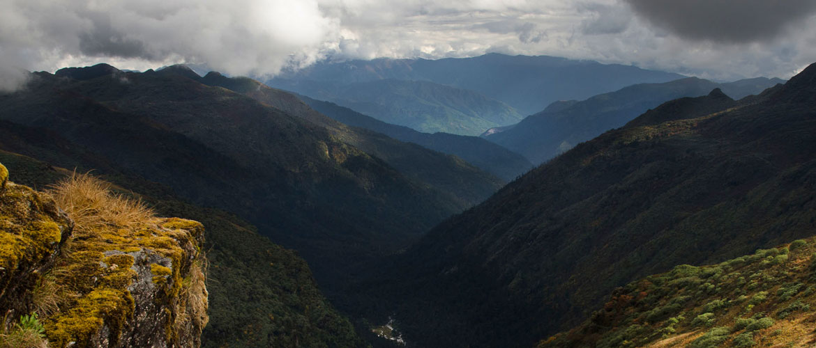
Day 06: Phokpey – Pemi
Today your trail takes you through crossing Rodung La Pass which lies at an elevation of 4160m. It is the highest pass on this trek. The trail from Phokpey to Rodung La Pass is negotiable with a uphill ascend through rich alpine forest and takes around two hours to rich the top. The top is marked with Chorten (stupa) and colorful wind flags surrounding it. From the pass thr trail takes you downhill through steep descent of nearly 2500m until you reach the valley floor. En route you will encounter with small meadow with forest covered with blue pines and conifers trees. Your campsite lies at an altitude of 2950m. The trail can be covered within seven hours and has 20 km from the start to the campsite.
Day 07: Pemi – Khaini Lhakhang
Your trail leads you through meadow filled with dwarf bamboos and then as you continues the vegetation gets changes to the forest covered with ferns and rhododendron trees along the trail. Your trail takes you through small ascend and steep descend till you reach Sang Sangbe(2300m) and finally drops downhill through the side of the ridge over a stream at 1700m passing through several villages en route like Ungaar Village and Zhobi Village. Traversing in and out through several landscape and valleys the route finally takes you to your campsite near Khaini Lhakhang at an elevation of 2010m. Distance covered:21 km and takes around seven to eight hours.
Day 08: Khaini Lhakhang – Tangmachhu
After passing through several side valleys, the trail then takes you through a tree line with a gentle ascend and then through side valleys until you reach another easy and small pass at 1940m which is known as the Zerim La Pass. After crossing the pass the trail takes you through the tree line, several remote villages, terrace rice fields and then finally takes you up to the Tage La Pass (1760m). From the beautiful pass the route takes you downhill through beautiful landscape and finally reach your campsite at an elevation as lowly to 1700m at Tangmachu in far east Lhuntse District.
Day 09: Tangmachhu – Menji
Today your trail takes you through beautiful valley and through terrace of cultivated fields utill you reach your campsite at Menji village which lies at an elevation of 1800m. The campsite is located nearby the Darchu Pang Lhakhang(temple) lies amidst of field of flowers. Your trail takes around five hours and distance covered is 16 km.
Day 10: Menji – Pemi
Your trail begins with a uphill climbs through thick forest filled with mixed broad-leaved, ferns and creepers until you reach Pemi village at an altitude of 2450m. Distance covered 20 km and takes around seven hours.
Day 11: Pemi – Taupang Village
Your treks begins with uphill ascend until you reach the top of Dong La Pass which lies at an altitude of 3900m. The pass is unlike that many other pass that you crossed so far. It offers a magnificent view of the mountain and deep valley beneath. Crossing the pass as you proceed further the trail takes you all the way steep downhill through mixed evergreen forest until you reach your campsite at Taupang village at an elevation of 2450m.
Day 12: Taupang Village – Trashiyangtse
Your last day trial takes you all the way down dill through lush green forest covered with broad-leaved and ferns and red-berried palms. The trail also offers wide array of flora and fauna. Bird lovers can encounter variety of bird species along the trail. As you descent town hill the trail finally drops you to Trashiyangtse the eastern most district of Bhutan. Reaching Trashiyangtse you will be transferred to your hotel. The trail takes around 24 km and can be negotiable within eight hour.
Day 13: Trashiyangtse – Trashigang
Today morning before you drive to Trashigang, visit the notable Chorten Kora which lies just below the town of Trashiyangtse. It is probably the largest chorten in the country and was built in the year 1700 by lam Ngawang Lodey. The Chorten host two religious festivals and people from Indian state of Arunachal Pradesh also come to witness the festival. After the Chorten drive to your onward destination, the drive takes you through barren hillside and many interesting villages until you reach Trashigang. En route stop to visit the Gom Kora Goemba which is located just below the road in the undulating meadow along the river bank. It is one of the important site in the eastern Bhutan and dated back to eight century. The site was visited by Guru Rinpoche. The cave below large black rock that lies adjacent to the temple amidst vibrant lush rice field is the cave where Guru Rimpoche spent time in meditating and it is here where he left the imprint of his body. There are many stories to be unfold regarding the goempa and the surrounding areas. Drive to Trashigang and visit the magnificent Trashigang Dzong overlooking the valley below. The valley lies at an elevation of 3725ft/1137m. The dzong was built in seventeenth century. After the stroll around the Trashigang town.
Day 14: Trashigang – Samdrup Jongkhar or Fly to Paro
The eastern end provides an optional program. You can either choose to dive further south to Samdrup Jongkhar and then checkout via India, which takes around 500 km drive from the bordering town until you reach Guwahati airport (India). OR you can drive back to Paro. Depending upon the flight schedule, you can also fly back from Trashigang to Paro, which is much easier and convenient.
Day 15: Depart
A sensational take off