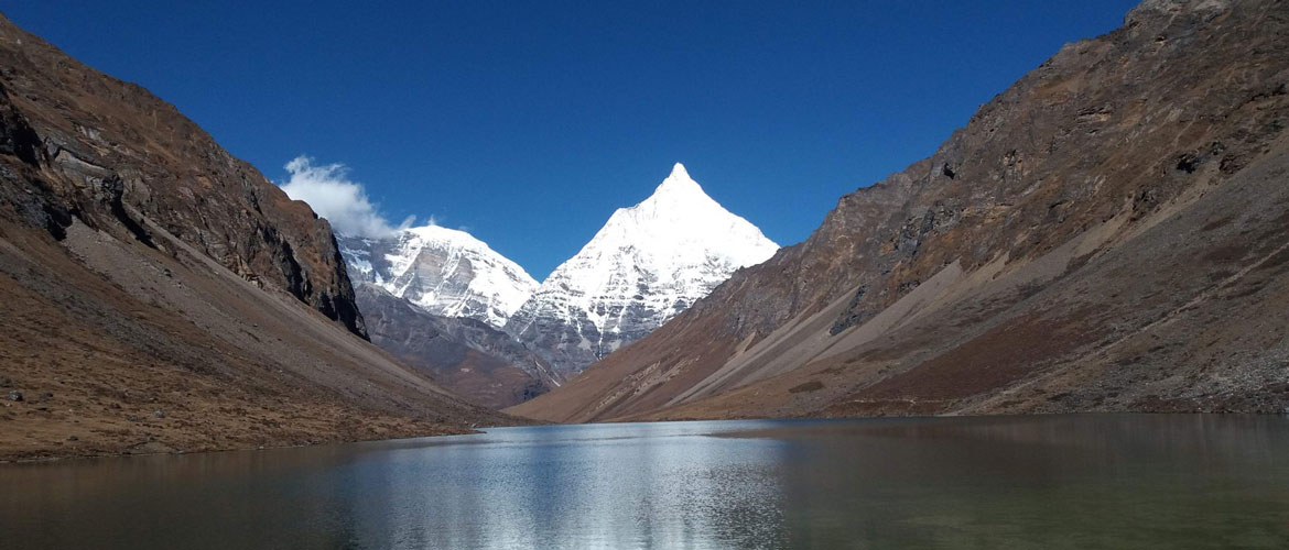
Mount Jomolhari (7,326m/24,035ft) is one of the most popular mountains in Bhutan. As such, the Jomolhari Trek is also one of the popular treks and it goes all the way up to the base of Mount Jomolhari. The altitude steeps up from 2,500 meters to nearly 5,000 meters and the trek offers majesty of experiences in landscape, flora and fauna. The highlight of the trek if the spectacular view of Mount Jomolhari from the Jomolhari Basecamp, Jangothang.
Duration: 9 Days
Detailed Itinerary
Day 1: Gunitsawa Village – Sharna Zampa
Walk for 40mins, 80 m descent, camp altitude 2,850 m.
The trek begins at Gunitsawa Village in Paro from where you will pass an army outpost. At the outpost, you will have to produce the trek permit, which will be provided to you by us (your tour operator) where it will be endorsed. The campsite is on the opposite side of the river not far away from Gunitsawa Village.
Day 2: Sharna Zampa – Thangthangkha
Distance 22 km, 7-8 hours, 770 m ascent, 10 m descent, Camp altitude 3,610 m.
The real trek begins from today. Brace yourself up. The initial trail is undulating with small uphill and downhill walks. Then it is an uphill walk through a river valley after which the valley narrows down to a path descending to a meadow where you will camp for the day. On a clear day, you will have the first view of Mount Jomolhari.
Day 3: Thangthangkha – Jangothang
Distance 19 km, 5-6 hours, 480 m ascent, Camp altitude 4,080 m.
The morning trek is up the Paro Chhu valley widening into patches of alpine meadow and scanty forest growths. You will cross an army checkpoint along the way and enjoy a spectacular view of high mountain ridges and snow-capped peaks. In this area, yak herder’s homes become a regular feature of the landscape. You will pass through the villages of Soe, Takethang and Dangochang. After reaching Jangothang, you will again have a spectacular view of Mount Jomolhari.
Day 4: Jangothang Halt
Today is a good time for you to acclimatize to the subalpine conditions. You will get ample time and opportunity to view Mount Jomolhari and Mount Jichudrake. You will also have time for day hikes, which will offer you amazing views of alpine lakes and snow capped mountains. If you are lucky, you can spot some blue sheep on the upper slopes of the valley. You can also trek up to Tosoh or hike around the area. There are good short hiking trails in three directions. Jomolhari and its subsidiary mountain chains lay directly west, Jichudrake to the north and there are a number of unclimbed peaks to the east.
Day 5: Jangothang – Lingshi
Distance 16km, six to seven hours, 810m ascent, 1,090m descent, camp altitude 3,800m.
The trail leads to a last settlement in the valley and drops to the Paro Chhu. Passing the lake of Tshophu (4,380m), you will climb up steeply to Bhonte La Pass at 4,890 m, the highest point of this trek route. Reaching the Dhumzo Chhu River, you trek downstream passing the few houses of Soi Yaktsa (Dhumzo) to arrive at your camp.
Day 6: Lingshi – Shodu
Distance 22km, eight to nine hours, 940m ascent, 920m descent, camp altitude 4,080m.
The trail climbs up to the Yelila Pass at of 4,930m. From the Pass, on a clear day you will get an excellent view of Jumolhari, Tserimgang and Masanggang. The trek from the Pass to the campsite at Shodu is a steep downhill.
Day 7: Shodu – Barshong
Distance 16km, five to six hours, 250m ascent, 670m descent, camp altitude 3,710m.
The trail follows the Thimphu Chhu through rhododendron forests, past beautiful waterfalls along the way. The valley narrows till the path takes to the slopes and gradually ascends to the ruins of the Barshong Dzong.
Day 8: Barshong – Dolam Kencho
Distance 15km, four to six hours, 290m ascent, 640m descent, camp altitude 3,320m.
The trail descends down to the Thimphu Chhu river valley, through dense forests of rhododendron, birch, conifer, maples and bamboos and then ascends to pasture lands. The camp is in a meadow.
Day 9: Dolam Kencho – Dodena
Distance 8km, three to four hours, 500m ascent, 930m descent.
The trail continues through forested areas winding up and down and through a small pass. Langurs (monkeys) can be seen along the way. In Dodena, you will exit the Jigme Dorji National Park and reach the road head next to an impressive cantilever bridge.
Jomolhari Trek – Concludes
The trek concludes at the beautiful Cherri Monastery, while it is a 40 min hike to the monastery.